Vertical Mapper 3.0
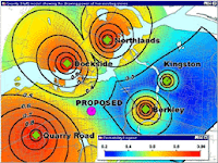
 Enhance geographic data analysis and visualization with the power of grids. Working seamlessly within MapInfo Professional, Vertical Mapper is unmatched as an effective tool to display, manage, and interpret spatial information. Optimize the location of broadcast towers, analyze health issues, visualize elevation, model environmental data, target marketing campaigns, determine centres of criminal activity – the possibilities are endless. Vertical Mapper lets you turn data into valuable information for making better decisions.
Key Advantages
 Create Grids
Vertical Mapper features modeling tools and a full suite of interpolators based on all standard estimation principles that let you build continuous surfaces, or grids, from existing point files or unmapped tables, regardless of data type. Easy-to-use wizards help novice users achieve meaningful answers while experienced mappers can adjust advanced settings to obtain more sophisticated results.
Display Grids
Visualize trends in spatial information easily. Vertical Mapper grid colour settings define data variations and dynamic 3D rendering tools let you bring data to life. View multiple grids within the same scene, apply drapes to any open grid, and determine the degree of transparency for both grids and drape files. Vertical Mapper gives you a wealth of display options to generate impressive and intelligent data representations.
Analyze Grids
Enter a whole new world of geographic analysis made possible through grid technology. Whether you need to query and compare multiple layers of information, use complex mathematical expressions to create derivative grids, or perform line of sight analysis with the ViewShed function, Vertical Mapper has robust spatial analysis capabilities that help you gain new insight from your data.
Download File
Password : free-gis-archive.blogspot.com
Comments
Popular Posts
-
MapInfo location intelligence enables you to answer a fundamental, yet complex question faced by nearly all organizations: Where? It's a...
-
AutoDesk AutoCAD Map 3D 2010 | 3.18 GB AutoCAD® Map 3D software enables engineers, planners, mapping technicians, surveyors, and GIS prof...
-
ArcEngine Developer Kit 9.3 Full | Rapidshare 24 Part ArcGIS 9.3 Engine Developer kit + Runtime Highlights * Support for Visual Stu...
-
Mapinfo MapXtreme 2008 | 124 mB | rapidshare MapInfo MapXtreme can put mapping applications into the hands of anyone with access to a web...
-
Leica GEO OFFICE 8.3.0.0.13017 GNSS - FULL With Leica Geo Office use the most powerful tools all integrated in one common soft...
-
PCI Geomatic 9.1 Full Geomatica Focus – a state-of-the-art work environment that includes a fully georeferenced, file-based visualization to...
-
National Geographic Maps Complete Collection - 8 CD ISO OS: Windows | CD ROM - 8 CDs | 5.06 GB Travel around the globe and through time with...
-
Google Said " Over the last 10 years, businesses, scientists and hobbyists from all over the world have been using Google Earth Pro...
-
ISBN: 0764569333 | Year: 2004 | PDF | 14.6 MB | 408 Pages Basic GPS principles and concepts such as waypoints, routes, tracks, and coordi...
-
Portable Universal Maps Downloader v4.0|| 1.95MB Universal Maps Downloader is a tool that help you to get small tile images from google...


